Minneapolis’ comprehensive plan for 2040 is big on framework, short on details. That’s the takeaway from a June 14 meeting at the Hennepin County Library on Central Avenue. The plan was presented in broad strokes by City Council Member Kevin Reich, Heather Worthington, director of long-range planning for Minneapolis, and Catherine Sandlund, principal/planner for the city. They met with a group of approximately 60 people from neighborhoods in the First Ward.
What is a comprehensive plan?
Worthington explained that comprehensive plans go back to 1980, when Minneapolis filed its first one with the Metropolitan Council. It provides a framework for planning more detailed policies in specific areas. Minneapolis 2040 addresses 14 areas of concern.
(The Met Council, incidentally, was formed because there was a need to deal with waste water in the Twin Cities area. It’s the reason the Pig’s Eye treatment plant was built in St. Paul. The idea was to control growth by regulating which cities could tie into the waste water system. A total of 87 communities are part of the Met Council, and all must file a comprehensive plan every ten years.)
Reich said the plan makes the city take a good, hard look at itself. “What are the key things that have changed [in the past ten years] that we need to address? People are coming back to the city. We are dealing with growth.”
And the city can’t work in a vacuum. The Met Council requires that Minneapolis coordinate with communities with which it shares boundaries, such as St. Anthony and Columbia Heights. Former City Council Member Paul Ostrow, who attended the meeting, added, “There has to be a balance between neighborhood planning and city planning, too.”
A history of development in Minneapolis
Worthington noted that in the “nineteen-teens,” Minneapolis had a lot of multi-family housing. Families often shared duplexes or had apartments above a commercial building. “Housing diversity was very common in the ‘20s,” she said.
At a 2040 meeting this past winter, and in the plan, it was stated that in the 1920s, Minneapolis zoned many single-family-
only areas. Also at that time, racially-restrictive covenants became a “thing.” White property owners used them as a means of blocking people of color from buying property in certain areas, drawing an imaginary “red line” around them. The eastern part of Audubon and the Stinson Triangle neighborhoods were under such redline covenants. See mappingprejudice.org for an interactive map.
In the 1940s, the federal government identified people who were considered poor candidates for underwritten loans, based on racially-restrictive covenants. In effect, it created cities of “haves” and “have-nots” and contributed to racial segregation by neighborhood. In 1948, the Supreme Court ruled that the covenants were unenforceable.
The 1940s also brought in World War II. In Minneapolis, there was a labor shortage at the armament plants, and some 20,000 workers from other areas needed housing. People voluntarily converted their homes to duplexes.
Worthington said housing usage has changed. “In the 1950s, there were three to five people living in the average Minneapolis home. Now there are two.”
Added Reich, “In the 1990s and early 2000s, people were leaving the city.” The Met Council projects Minneapolis’ population will exceed the highs posted in the 1950s.
Transportation, job access, intertwined
Worthington said the Met Council expects the area’s population to increase by 80,000 residents by 2040; that works out to about 49,000 new households. She said the city is looking at vacant properties that may be available for development. “We are not recommending up-zoning the entire community, but it’s a waste of space to build a four to six-story building downtown,” she said.
The Met Council has charge of the bus system and the light rail lines and is trying to bring service to areas of greatest need. “Job access drives housing, which drives transportation,” said Worthington. She said 20 percent of Minneapolis’ land once was used for manufacturing facilities that
offered good-paying jobs. Now 3 to 5 percent of land use is dedicated to manufacturing. Part of the comp plan seeks to find ways to re-establish jobs where people make things.
A unique approach
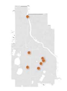
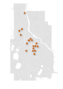
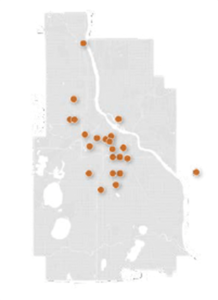
In the past, the Minneapolis Planning Commission received a questionnaire from the Met Council and checked off the boxes, Worthington said. The Minneapolis 2040 Comp Plan is different because planners actually sought citizen input at various meetings around the city. Citizens can continue to have input, too. You can access the entire comprehensive plan draft at https://minneapolis2040.com/. Comment boxes accompany each topic of the plan (housing, transportation, job access, the built environment) where you can register your opinion. Each ties directly to that specific area. Comments are tallied and stored verbatim. The public comment period ends July 22. A final draft of Minneapolis 2040 will be ready by this fall.
Below: Maps from the comprehensive plan show where in the city the 2040 plan engagement events were held prior to the current report. Do Northeast and other lower-density residential neighborhoods have some catching up to do, on giving input?