In the grand schemes for the upper Mississippi riverfront, Northeast got Hall’s Island and “Parcel D.” North Minneapolis will get an amphitheater, a first step in “build it, they will come.”
That’s oversimplifying, of course. Planners from the city of Minneapolis and the Minneapolis Park and Recreation Board hope to begin public infrastructure and park construction in 2020-2021. It’s a multi-phased plan for the former Upper Harbor Terminal (UHT) area that intends to connect with and benefit North Minneapolis residents and businesses.
They’re deliberately starting at the far northern end of the 48-plus acre, almost mile-long site to be as far away as possible from known air pollution and odor sources.
The amphitheater, which would be programmed by First Avenue, has a covered outdoor stage. Concert goers watch from three stories of seating and a gantry that connects the two areas, for a total of 6,000. Behind them is lawn seating for another 4,000 that is otherwise a public space approximately 315 days a year. The stage can be closed off from the elements for winter events.
In capacity, it compares to 6,000 at Surly Festival Field (the new venue would hold 10,000). The Xcel Center holds 18,568 and Target Field holds 40,000.
The stage can be enclosed for winter events.
Admission to the approximately 50 events that First Avenue books would include a per-ticket fee to support other free culturally relevant public programming by long-standing North Minneapolis nonprofits.
Planners pointed to the success of concerts in the last few years held on the Hall’s Island site in Northeast as evidence that there is demand for a permanent dedicated concert venue.
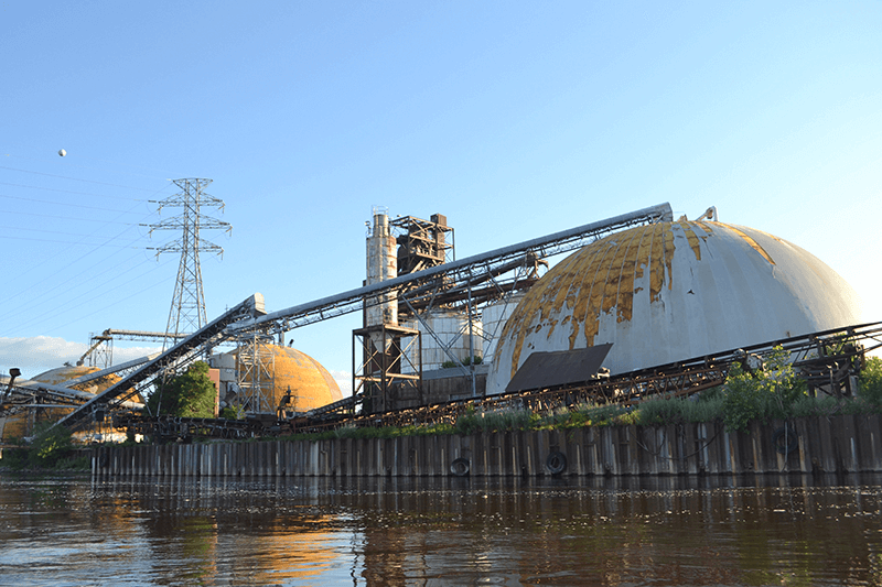
The concert venue would nestle to the north of a pair of domes and four silos that sit south of Dowling, which would remain in a “relics park.” There was a lot of support for keeping a historical industrial feel to the area.
It’s anticipated that sound from the venue would not carry far enough to affect neighbors, though freeway sound from I-94 could affect concerts and would need buffers. And that’s where some office/commercial and residential/commercial buildings come in behind the public seating, along the south edge of Dowling Avenue on both sides of Washington Avenue. There would be about 150 units of housing, 115,000 sq.ft. of office, a total of 25,000 sq.ft. of commercial. A 110- to 180-room hotel with 15,000 sq.ft. of commercial would sit just north of Dowling.
A three-story Community Innovation Hub of office, production and education uses would go up at approximately 36th Avenue North. The rest of the strip along the river south to GAF would be surface parking for the concert venue until it could later be developed and parking ramps be provided.
At the shoreline, various types of restoration and connection would occur, with a plaza at Dowling suitable for outdoor markets, a promenade along the concert venue where people could stand at a railing on the existing seawall and view the river; in all, creating about a mile of public waterfront and 15.5 acres of public park.
To pay for it all:
A state general obligation bond of $15 million and city and park board contributions of $16 million will get the site clearance, street network/access, park improvements, utilities and storm water management underway. They are also looking at improving the existing Dowling bridge over the freeway to make it more pedestrian friendly.
Ideally, power lines need to be relocated to run along the rail corridor at the back of the site and to cross the river south of the new concert venue. Currently they cut through the air space above the domes.
For the concert venue, the city and park board anticipate going to the state Legislature for a bonding request of up to $20 million, plus conducting a significant capital campaign. Between the concert venue, hotel, and subsequent business development, planners say that the destination is the catalyst that would project a desirable image of North Minneapolis, paving the way for $125 million in private economic development.
The development team partner North Minneapolis-based Thor Construction, for example, is teed up, teamed with United Properties, to develop, own and lease out the business space and the housing.
Questions/challenges:
Kate Lamers of the park board and Ann Calvert of the city’s Community Planning and Economic Development department (CPED) presented much of the material, with D’Angelos Svenkeson of Thor Development, Brandon Champeau of United Properties, and Dayna Frank of First Avenue.
At the August 15 daytime session, North Minneapolis activist and school board member Kerry Jo Felder and others encouraged the planners to make 70 percent of the housing affordable through subsidy, instead of the 20 percent planned.
It was established that whenever “area median income” is talked about, that it is meant to apply to North Minneapolis’ median income and not the overall metro area, which would be higher.
There was discussion of how the area fits into the Minneapolis 2040 comprehensive plan. Limited to six stories because of being located in the Mississippi River Critical Area, a total of 1,000 housing units could eventually fit on the site as planned. The 2040 plan slates the area for corridor mixed use, which includes housing, and production mixed use, along with parks.
From the August 15 and 16 meetings, selected questions and answers summarized:
Q: Describe the pay for the jobs on site.
A: 50 percent of the jobs will be minimum-wage based, including tipped jobs, which yield more. Security jobs pay 1.5 to 2 times those, and 20 percent would be considered good paying.
Q: Will there be Metro Transit enhanced bus service?
A: In preliminary conversations with Metro Transit. We hope they will provide bus service; they are challenged to maintain what they have.
Q: Are you taking proposals for use of space?
A: Yes, send to Dayna Frank at First Avenue Productions.
Q: What if the amphitheater proves not viable?
A: The land would revert to the city and the space could be re-programmed.
Q: Would the housing be allocated by lottery?
A: No, first-come, first-served.
The Q&A from all sessions will eventually be posted on upperharbormpls.com.
Both the City Council and the Park Board will need to approve a plan, and additional funds will need to be applied for, to make everything happen. Again, with the money that is already committed, and when a plan is approved, public park and infrastructure shovels could start digging in 2020 or 2021.
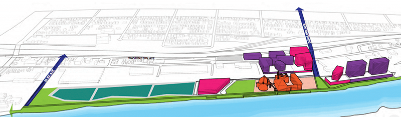
Below: Graphic shows the concert venue in orange, 33rd Avenue and Dowling Avenue in dark blue at left and right. Pink shows the Community Innovation Hub at left, the first housing units, and to the right (north) of Dowling, the hotel, all part of the first phase. The purple masses are spots for additional housing and businesses in a second phase. Teal parcels are the third phase, to be determined. The green areas are parkland including riverfront. (Graphic courtesy of upperharbormpls.com, where the entire plan is posted online.) A robust discussion occurred Aug. 28 including pleas to see this as a regional resource as well as benefit for North Minneapolis. Watch MyNortheaster.com for further updates.